
I ended up staying an extra day on my trip and got back today late afternoon. I was a bit tired from yet another multi-legged journey and feel just a slight bit of a cold coming on (alas, I hung around a number of sickly folks….). More of my woes include it being fairly cold out, so I decided to start back in on the build with something a bit “low key.”
As many of you probably know, every year Seattle Avionics has an outstanding Black Friday sale where they provide lifetime subscriptions on their data at nearly half price for all the major EFISs, including Garmin, Aspen, Dynon, AFS, and yes, GRT. The map data they provide is geo-referenced sectionals, hi/low IFR charts, approach plates, and airport diagrams.
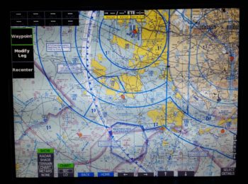
As to how good all this is, I’ll sum it up as someone said on the GRT forum: The charts are ok, but zoom out to past a 100 nm view and they’re virtually useless. I suspect that having the ability to zip around the map with a touchscreen EFIS (ahem!) makes them a bit more useful… somewhat analogous to using an iPad. The forum poster went on to say that the geo-referenced approach plates and airport diagrams more than made up for what the charts were lacking.
I still wasn’t going to pull the trigger until next year since, honestly, I still have quite a trek left to finish this airplane. However, when I got the email (and I’m glad they sent it) that said this was the last year of their deep-discounted Black Friday sale, I decided it was time to reluctantly break out the wallet. Moreover, having seen Black Friday sales in the past from other airplane related suppliers (ACS, Wicks) that are no more, I figured they weren’t kidding and for nearly half the price, I wasn’t going to take the chance that they were.
I started out by downloading Seattle Avionics DataManager Program that allowed me to pick what charts I wanted, including charts they offer for all of southern Canada, a bunch of Mexico, the Caribbean and the Gulf of Mexico… pretty nifty.
After downloading the data from the Seattle Avionics server, and then uploading it to a 32GB SanDisk thumb drive [which was a multi-hour endeavor to find and purchase] that needed to be pressed into service vs. the originally GRT supplied 8GB USB stick, I was quickly able to bring up the IFR low chart on my EFIS. Again, pretty nifty!
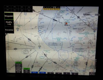
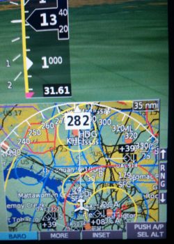
I then played around with the sectional chart for a bit. BTW, the guy on the GRT forum was correct: anything out past a 100 nm resolution and these charts are really not very useful.
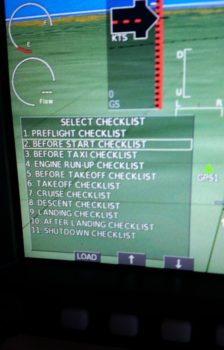
I then had an issue where I couldn’t load up the approach plates, so while I messed about with trying to figure that out I decided to build my aircraft checklists and load them up into my HXr.
When Marco bought the superb Long-EZ that Terry Lamp built last year, he tweaked the checklist for a much more logically flow. He provided me with a copy and that’s what I used for the boiler plate to create these checklists. I then spent quite a few hours (as I was slowly uploading all the chart data for the surrounding states in my area) tweaking and updating the checklists with items relevant to my specific configuration.
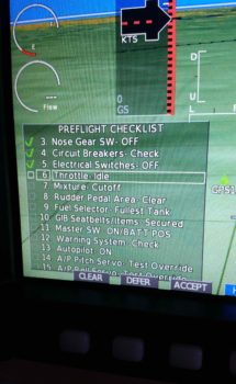
On the left is a list of all the checklists I’ve created so far, and on the right is an example in the Preflight Checklist of each item getting checked off as it is completed. At first I wasn’t sure if I would like these on-screen checklists, and to be certain I will have a hard-copy version [that’s all I’ll have for the external walk-around part of the preflight], but I can see myself adapting to using these and not messing about with any physical checklist in the cockpit . . . especially when it ends up somewhere where it’s not supposed to be!
I wanted to show this shot of the right map inset (it can be located on either side, I just happen to keep it in its “default” location) with all the ADS-B traffic buzzing around. I live a few miles south of DC’s Reagan National Airport, so not surprisingly it shows a lot of traffic.
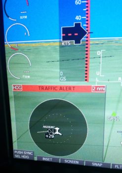
Moreover, my being in the traffic pattern affords the HXr to showcase one of its really cool features that I’m sure I’ve discussed previously: when traffic enters into an area that I’ve defined in the settings, it lights up the left inset with a Traffic Alert, as shown below. It will stay active as the left inset until the traffic has traveled outside those predefined distance parameters, at which point the inset will revert to what I had there before: typically an engine info screen detailing EGT and CHT data.
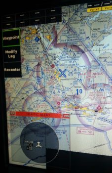
With the sectional chart up, I meandered my way down to the North Carolina coast where I plan to be living next year. While “visiting” down there I got a visitor in the way of another traffic alert. I love this feature so I grabbed another shot of it… no more pics of these, I promise (in THIS post!).
As I was finishing up this post, Jeff from GRT called to help me out with the case of the missing approach plates (key dramatic music!). Well, apparently I didn’t quite understand the process, and mind you it’s not specifically written down anywhere. Thus is the plight of us GRT users… yes, the learning curve may take a bit, and what it can do is not always straightforward, but I am constantly amazed at how versatile these EFISs are… but I digress.
I was trying to LOAD the approach plates into the EFIS by copying them over from the USB stick, which I didn’t realized simply can’t be done. Although I knew there was a lot of data, there is so much data that the EFIS merely reads it all off the thumb drive… much in the same manner, but way faster, as our Commodore 64 computers read the data off cassette tapes…ha!
Before Seattle Avionics came up with these nifty Geo-referenced plates, the only original method in play to get approach plates displayed on the EFIS (when GRT enabled the capability to do so) were PDF plates. These PDF plates are still a viable option and they’re free, but not geo-referenced. So the menu item still shows “copy” as a means to bring approach plates (ahh, but only PDF plates) onboard. For “chartdata” plates, in reality one simply just needs to go select an approach at an airport and load ‘er up (I had tried this early on but it didn’t work… it of course worked fabulously while I was on the phone with Jeff from GRT, so he called to confirm that there was actually no problem… haha!) Oh well, at least its working . . .
Below is a shot of a quick Direct-To flight plan I ginned up down to Chesapeake (I hope Marco reads this to know I’m coming to visit!) and the approach plate that I just learned how to effortlessly pull up.
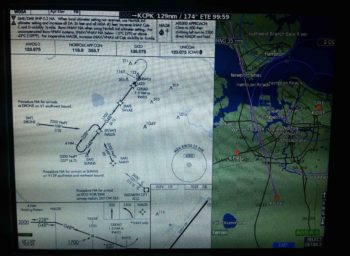
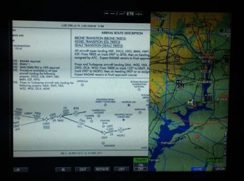
Here’s a shot of a STAR (Standard Arrival Route) plate that I pulled up for BWI. The EFIS provides a way to turn, pan, zoom, etc. the plates to ensure you can see what you want. There are also other EFIS views with the approach plates (e.g. just the plate) if I wanted to set it that way, here I was just confirming that they worked.
Ok, so with the EFIS data and checklists squared away, tomorrow I will finish finitely planning out my build tasks over the holidays and for the next couple of months.